A large and growing number of technology tools is being used to engage the public in transportation and land use planning. Many of these tools are visualthey help citizens visualize alternative scenarios, and, thereby, build a deeper understanding of alternative policies, trade-offs, and planning solutions. The wealth of visual information that technology-based tools provide can help people make more informed decisions and reach consensus on their communitys full potential.
Public meetings, workshops, and charettes have long included photographs, drawings, maps, and scale models, as well as visual preference surveys in which participants identify the design features they like or dislike from a series of still images of streets, parks, houses, public spaces, and buildings.
Today, however, such techniques are often supplanted by computer-aided programs.
Geographic Information Systems (GIS) Mapping
GIS, at the most basic level, can be thought of as computerized mapping. Databases are linked to maps and computer-generated graphics. When a database is updated, the related map or graphic is updated as well. Digital maps and graphics can be layered on one another, creating a powerful, visual, decision making tool.
GIS databases may cover a wide variety of demographic, geographic, environmental, political, and social information. GIS mapping can be used to help citizens and other decision makers understand alternatives under different land use patterns or different economic or environmental conditions. GIS is also used frequently to make decisions about creating new multi-use trails, routing buses and emergency vehicles, protecting wetlands, and siting new facilities, to give only a very few examples.
Many county and municipal governments in the region put their GIS data and associated information online for users to interactively view and query at their convenience.
People may think of ArcGIS and other desktop programs when they think of GIS, but the most popular GIS applications include Google Earth, Twitter (every time you tweet, you add to a geo-database), and MapQuest driving directions. In a word, GIS is everywhere. Its the foundation of many, many technology-based planning tools.
Microsimulation
Participants in GTC-sponsored planning studies may hear that consultants use Synchro or VisSim or other software to analyze technical data. These are GIS-based programs that are used to model the movement and behavior of motor vehicles under different scenarios. For example, they may be used to examine and visualize the capacity of intersections under different conditions.
Synchro, VisSim, and similar programs deal primarily with functionhow our roads work. But successful community planning goes beyond function to include context, form, and aesthetics, and, to capture these, other technology tools are available.
Community Planning Tools
For better or worse, a bewildering array of technology tools are designed to increase the involvement of those most affected by public decisions and to help the public evaluate the benefits and costs of alternatives.
A primary resource on the large number of technology-based tools available for planning and decision making is the Orton Family Foundation. The Foundation provides comprehensive information on such tools and advises communities on the best tools to use for particular situations and how to use them.
A few examples of community planning tools:
COMMUNITYVIZ
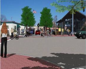
CommunityViz is a popular, user-friendly GIS-based program that allows citizens to analyze, visualize, and discuss important land use and transportation decisions. Users can create realistic 3D images of their world as it is now and as it could be under different scenarios.
INDEX
INDEX is the name of a suite of interactive GIS-based planning tools that can help assess community conditions, visualize and compare alternatives, and monitor the implementation of an adopted plan. One version of INDEX is PlanBuilder, which emphasizes urban design and multi-modal transportation at the neighborhood level. Another version is Paint the Region, for envisioning and evaluating land use and transportation scenarios at the regional scale.
MINDMIXER
MindMixer is a virtual town hall where citizens can contribute ideas about what they want and need in their communities. Users sign up with their real names, pick personal interests and locations, then can raise issues on an online forum or respond to posts by elected officials, municipal departments, and school districts.
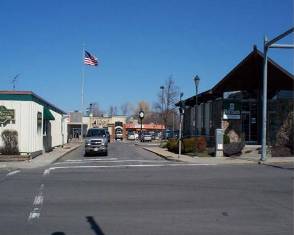
Computer simulations can accurately represent how a recommendation will look when built, providing the public with a more realistic sense of the future of their communities than a set of engineering drawings or an artist's rendering.
Selected Resources
- Orton Family Foundation
Information on the availability, appropriateness, and use of technology tools for concerned citizens, professional planners, and public agencies.
- Planning Tool Exchange
An online hub for highly-regarded tools, resources, and organizations in community planning, sponsored by the Orton Family Foundation.
- Transportation Planning Capacity Building
An online reference developed by the USDOT of traditional and innovative public involvement techniques for community transportation planning.
- Design Visualization Guide
From the Federal Lands Highway Division of the FHWA, this site offers information, tutorials, and case studies about visualization techniques in transportation planning.
- Smart Planning
The New York State Department of Transportation's resource for planning for transportation and land use investments that contribute to sustainable economic growth and quality of life.